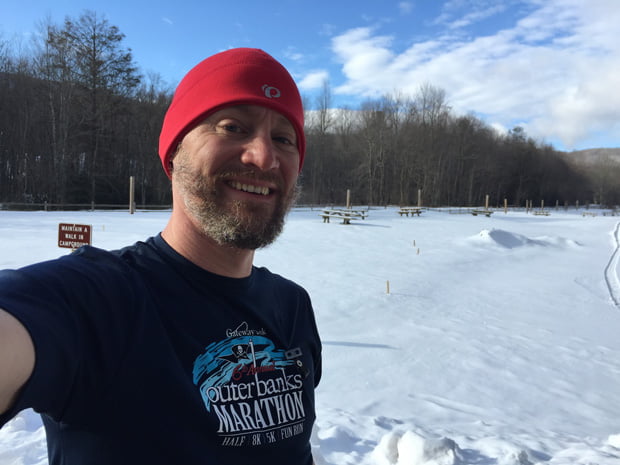
For our annual winter backpacking trip, my buddy, Coop, and I decided on Mt. Rogers Recreation Area. We’d been there in 2011 when we hit up Grayson Highlands to see the wild horses. It’s a great place with great views, and it’s also home to the highest point in Virginia. What makes Mt. Rogers Area a particularly good spot for the winter is the number of trails through and around the area. A must when weather forces routes to change. Something that often happens at Mt. Rogers where winds and temps are known to change in minutes.
Still, we opted to plan our trip ambitiously and play the rest by ear.
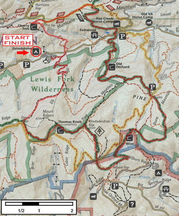
PLAN A: Grindstone/Fox Creek Loop (24.8 miles)
Starting at Grindstone campground we’d take the Mt. Rogers Trail to Deep Gap (4 mi) where we’d ride the AT north to VA603 (14.8 mi) and then to Chestnut Flats (2.3 mi) where we’d head west on the Iron Mountain Trail to Cherry Tree Shelter (2 mi) and finally south on Flat Top Trail back to Grindstone (2.1). It’s a long route, but there are plenty of creek crossings and shelters.
WEATHER FORECAST
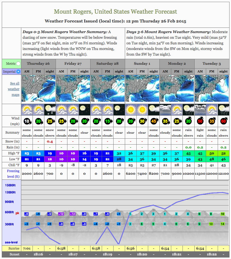
In the weeks leading up to the trip we closely watched the mountain forecast. The Thursday before our trip the forecast was calling for -41ºF wind chill with 40 mph winds. Holy F$%#! Thankfully, the cold snapped and we were only facing a day of near single digit temps and wind chills in the negatives, a day in the teens, and a day just above freezing. Overall, not too bad, well, mostly.
If you look at the forecast below you’ll see a chart displaying the freezing level along with the temps at those elevations. Yeah Friday was looking pretty cold, and Saturday night wasn’t going to be all that great either. Then, with just two days before our trip, a fresh load of snow fell from the heavens and blanketed the ground forcing us to consider an alternative route.
PLAN B: Fairwood/Chestnut Loop (22.9 miles)
In light of the westerly winds and frigid temps, Coop suggested we camp low and on the eastern side of the mountain. The new plan was to park at the Fairwood lot and take the AT down to Scales (~4 miles). Head south on Virginia Highlands Horse Trail (½ mile). Turn onto Wilson Creek Trail to Wise AT Shelter (¾ mile). Wise to Rhododendron Gap (4.25 miles) Rhododendron to Deep Gap (3 miles) Deep Gap to Grindstone (4 miles). Grindstone to Cherry Tree (1.7 miles) Cherry Tree to Chestnut Flats via IMT (1.7 miles) Chestnut to Fairwood parking lot (3 miles).
With the plan solidified (for now) there were a couple other items for consideration: shelter and snowshoes.
Shelter. I’ve been using an ENO DoubleNest hammock for my most recent trips, and wanted to see how it held up in the cold. The plan was to hang the hammock under a rainfly and sandwich it between a topquilt and underquilt. While the fly would probably, maybe protect me against the winds, the quilts only had temperature ratings of 30-40ºF. Given how cold it was going to be I bailed on the hammock and opted for my tent, a pad, and a zero bag.
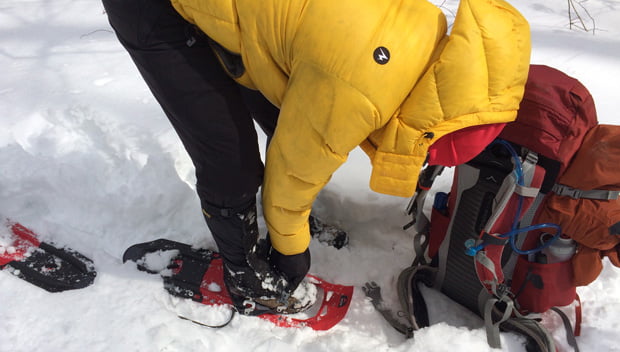
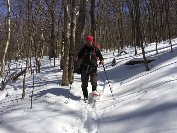
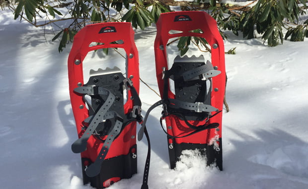
Snowshoes. Last year we rented snowshoes when we packed Dolly Sods. This year we figured we’d rent ’em for Mt. Rogers. Coop found a place near him that rented for $15/day. They weren’t open on Sunday and the store was about an hour from Coop’s place. With the cost of renting nearing the cost of a new/used pair, Coop bailed on snowshoes and I turned to the Internet. A couple days later I decided on MSR EVOs and 6″ tails. They arrived a couple days before the trip, and just in time for my son to give ’em a try.
With snowshoes thoroughly tested, bag packed, and car loaded I headed out to Fairwood. Upon arrival it was evident that the AT parking lot wasn’t going to work (I got stuck and Coop had to push me out) so we opted for the horse campground a quarter mile back on VA603 (which someone was kind enough to plow a portion).
DAY 1 (3 MI | +1,073′ GAIN | -16′ LOSS)
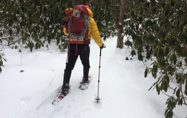
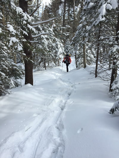
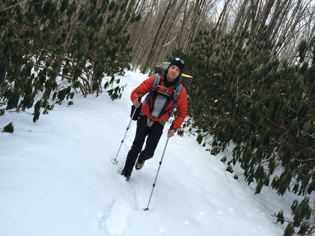
At 1PM we made the 1/4 mile hike from the car back to Fairwood and began our hike up the AT. The EVOs handled the deep, light, fluffy snow well. Coop’s boots, however, did not. With each step he took you could see the climb to the top was going to be a doozy. You see, on almost every trip we’ve taken, Coop has been 10-15 yards ahead of me. It is a rare occasion that I’m in front, and even rarer for me to be having an easier time than Coop. So, yeah, the snow was going to be an issue.
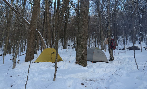
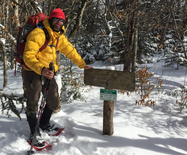
We reached the Old Orchard AT Shelter around 2:20PM. Given our current 40 minute per mile pace and the fact that we had 4 hours of daylight I pulled out the map and started to consider our alternatives. We decided to hike until 3PM and then start looking for a place to camp so we’d avoid the wind and colder temps at the higher elevations, and so we’d have enough time to set up and start a fire. We agreed to agree and found a spot about a mile up the mountain.
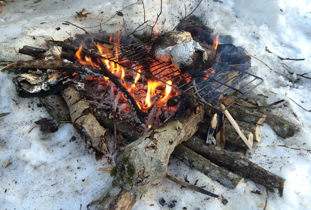
Coop got the fire going, I cooked brats and potatoes whilst whistling the theme from Jurassic Park, and then the two of us feasted.
The conversation bounced around before we talked about the elephant in the woods—Plan C.
If we continued at our current pace along our current route we’d be home sometime midweek. Since we both have jobs we opted to keep our trip to three days and change our route again. Instead of Scales we’d hike to the intersection of Pine Mountain Trail, then to Cliffside Trail, and camp for the second night somewhere along the creek just off Lewis Fork Trail.
DAY 2 (4.79 MI | +732′ GAIN | -1,414′ LOSS)
The first night was ridiculously cold. Snowmelt had made its way through my tent and onto my bag making my feet very, very cold. To make matters worse, the snow beneath my torso melted causing my body to slide towards my head. At some point in the middle of the night I woke up all bunched up and realized what was going on, and turned myself around with the hopes that I wouldn’t slide down the hill. Gravity crushed my hopes and dreams and the last few hours of sleep were pretty miserable. The silver lining of my frigid rest were the two 8-hour hand warmers that offered a shred of comfort.
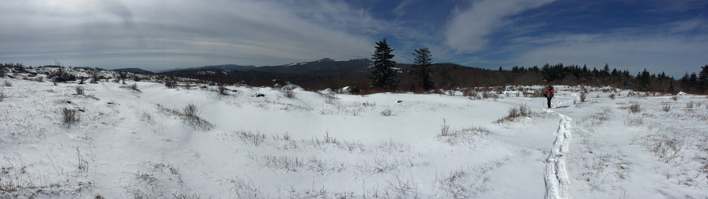
Around 8AM we woke, ate breakfast (I had coffee and frozen tuna), and broke camp. By 9:30AM we were back on the trail. Forty minutes later we finished the one mile, 462′ foot ascent from our campsite to the AT-Pine Mountain Trail intersection. It’s also where the perimeter fence is in place to contain the wild horses that roam the Recreation Area. Did we see any? Neigh.
We took a moment to see the sights before heading down Pine Mountain Trail.
Click to enlarge
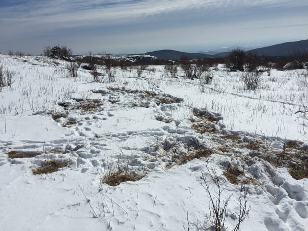
As we did we eventually popped back out on the bald where we came across a campsite used by the mountain’s horses (possibly from the night before).
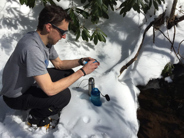
In the distance we could see the Pine Mountain – Crest Trail intersection. We turned S/SW and made a B-line for Crest Trail. Just through the trees there’s a spring and my hope for some fresh water. On approach all looked well. Off with the pack, out with the bottle, scoop, and then I saw something. Something very small and very wormy swimming around in the water. I let out a big “Nope!” and we continued on.
A few minutes later we hit the intersection, then crossed the field towards Cliffside.
At the base of the next hill we came across a sign for Lewis Fork and Cliffside Trails. The sign said Cliffside was northwest. Northwest was basically straight down the mountain. As we descended something didn’t feel right so we went back up and followed another possible trail before I turned to Coop.
ME: I don’t see any blazes.
COOP: The trail sign says we go that way [pointing northwest]. The map says the trail goes that way [pointing northwest] and shows the trail to be perpendicular to the contour lines [pointing to the map]. We’re in a wilderness area and there may not be any blazes. One thing is for sure. The trail goes northwest and that direction is definitely northwest [holding his compass].
His logic was solid and I was really thirsty so we went the way he and his compass pointed. Before long we came across a horse fence and I gave Coop a “Good call.”
After the fence the downhill was brutal. Seriously, it was ridiculous. My quads burned, and I was having a rough time navigating the trail with snowshoes.
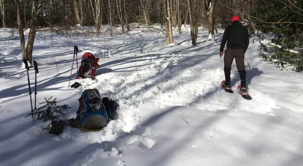
Eventually, finally, and thankfully, after a 40 minute, one mile, 1,000′ descent we arrived at a creek and all of its flowing goodness.
Bottles and bladders full, we continued down the trail, crossed onto Lewis Fork, and began to look for a campsite. About a tenth of a mile from the intersection Coop spotted a good place to settle down.
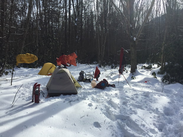
We ate Mountain House and sat around the fire for a bit. We agreed to wake at 6AM and hit the trails by 7:30AM. After polishing off my cigar, I turned in around 8:30PM (also because I’m old) and Coop hung out ’til 10PM (because he’s not old).
DAY 3 (2.29 MI | +23′ GAIN | -410′ LOSS)
I woke at 6AM and started grabbing gloves and hats and putting them in my sleeping bag to warm them up (and to buy a few more minutes of relaxation). By 6:20AM I was deflating my pad and rolling up my bag. Not too long after I had my tent broken down and bag packed. Coop just looked at me and shook his head. “It always amazes me how quickly you pack up.” What can I say, I like to get things done.
By 7:33AM we were back on the trail. The combination of fresh legs and a gradual downhill put an extra hitch in my giddy up. Also fueling the hitch were a pair of fresh cat tracks that we followed all the way down the mountain.
Within 20 minutes we were out of the woods and crossing a field just off VA603.
Now, we could’ve walked the road a mile to the parking lot, but we figured we’d stick to Fairwood Trail and find our way to the lot eventually. Sure enough, 40 minutes later we were peeling layers and packing our things.
FINAL THOUGHTS
Our plans changed. Our route was cut to 10 miles. It was cold. The wind howled. There was snow. Blah blah blah. You know what? Who cares? We had a blast! I love Mt. Rogers Rec Area. My only regret is that we didn’t see the mice, rabbits, turkeys, bobcats, and horses that we know were hanging out. Seriously though, given that that’s my only complaint, I’m gonna call this trip a success.
BTW, if you’re interested and want to give our route a whirl, you can download the KML route for Google Earth.